AIS is a tracking system used aboard ships and by vessel traffic services (VTS) to identify and locate vessels. It accomplishes this by automatically exchanging data with other ships, AIS base stations, and satellites. This data includes unique identification, position, course, and speed, providing a comprehensive situational awareness to all parties involved in maritime navigation.
The Rise of Mobile Apps for AIS Tracking
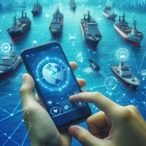
With AIS mobile applications you can see exactly where a specific ship is at any given moment, along with its direction and speed. This feature is invaluable for logistics companies coordinating shipments, family members tracking a loved one’s journey, or maritime enthusiasts following the progress of certain vessels.
Every ship that broadcasts AIS signals sends out a wealth of information. Mobile apps tap into this data stream, offering users detailed profiles of each vessel. This can include the ship’s name, size, type (cargo, tanker, passenger, etc.), flag, destination, and estimated time of arrival (ETA). Having such information at your fingertips is necessary for business operations and safety monitoring.
Creators emphasize intuitive design and ease of use. The goal is for anyone, regardless of their technical skill level, to be able to navigate the app successfully. With clear maps, straightforward navigation tools, and customizable alert systems, these apps ensure that you can quickly and easily find the information you need without hassle.
Many AIS mobile applications offer integration capabilities with other systems or platforms. For shipping companies, this could mean integrating AIS data into their existing logistics software, simplifying operations, and improving efficiency. For individual users, it could mean the ability to share vessel positions on social media or with friends and family, making it a versatile tool for communication and sharing.
Benefits of AIS Mobile Apps
The immediate tracking and advanced collision detection feature alert users to potential hazards, allowing for timely corrective actions to avoid accidents. By providing detailed information on vessel movements and locations, these apps contribute to a safer navigational environment for all seafarers, reducing the risk of collisions and grounding in congested sea lanes and poorly charted waters.
 Shipping companies can plan more efficient routes, monitor their fleet, and make informed decisions based on the comprehensive data provided by these apps. This leads to optimized voyage planning, fuel savings, and improved on-time delivery performance, offering competitive advantages in the global shipping industry.
The democratization of maritime information through AIS mobile apps has made it simpler for anyone with a smartphone to access detailed data on vessel movements worldwide. This accessibility benefits maritime enthusiasts, researchers, and families of seafarers, providing them with insights and peace of mind that were previously difficult to achieve.
Access to historical voyage data, routes, and behavior patterns of vessels allows companies to analyze trends, assess risks, and make strategic decisions that enhance safety and efficiency. This approach to decision-making can lead to significant improvements in route planning, fleet management, and overall maritime operations strategy.
By enabling more efficient route planning and fleet management, AIS mobile apps indirectly contribute to environmental conservation efforts. Optimized routes mean vessels can reduce fuel consumption and, consequently, lower their greenhouse gas emissions. This contributes to the maritime industry’s broader efforts to reduce its environmental footprint and adhere to international regulations aiming at sustainability.
Vessels equipped with AIS transponders can be tracked across the world’s oceans, connecting people and businesses like never before. Shipping companies can provide customers with real-time updates on their shipments, families can track the voyages of their loved ones, and maritime enthusiasts can follow the movements of ships globally.
The ability to track the current position of vessels makes it easier for authorities to locate and assist ships in distress promptly, potentially saving lives and property.
Choosing the Right AIS Mobile App
A good AIS app sources its information from a vast network of AIS receivers and satellites, ensuring comprehensive coverage and up-to-date information. Before settling on an app, investigate its data sources. Apps that are transparent about where their data comes from and how often it is updated are generally more reliable.
The right AIS mobile app should boast an intuitive interface that allows you to easily navigate through its features, without a steep learning curve. Consider apps that offer clear mapping, straightforward menus, and quick access to important functions like search and alerts. Trying out a few apps to see how their interfaces feel in practical use can be a very helpful step.
Look for apps offering detailed vessel information, collision detection alerts, historical data access, and customizable notifications. Depending on your specific needs, you might value features like port data, weather information, or the ability to integrate with other systems. Assessing which features are most important to you and ensuring your chosen app provides them is critical.
Many AIS apps offer a range of pricing options, from free versions with basic features to premium subscriptions offering advanced functionalities. Consider how you plan to use the app and whether the premium features justify the additional cost for your needs. Some apps may offer a free trial period for their premium service, which can be a great opportunity to test if the advanced features are worth the investment.
Look for reviews that mention how the app fares in terms of data accuracy, customer support, and overall user satisfaction. While no app will have a perfect rating, a pattern of positive reviews is a good indicator of quality.
The development team should regularly update the app to improve functionality, add new features, and fix any bugs. Apps that receive frequent updates are more likely to provide a better user experience and keep pace with the evolving needs of mariners and maritime enthusiasts.
Ensure that the app has robust measures in place to protect user data and respect privacy. This includes secure data transmission, clear privacy policies, and user control over personal information and settings.