AIS is a tracking system used on ships and by vessel traffic services (VTS) for identifying and locating vessels through data exchange with other nearby ships, AIS base stations, and satellites. This system utilizes VHF radio channels to transmit a vessel’s location, speed, course, and other pertinent data to all entities equipped to receive AIS information.
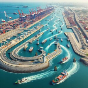
Congested waterways, such as ports, canals, and densely trafficked shipping lanes, present significant challenges for mariners and port authorities. The volume of traffic, combined with the complexity of operations, increases the risk of accidents and inefficiencies. AIS serves as the eyes and ears in these crowded maritime environments, providing a transparent overlay of real-time information.
Enhanced Situational Awareness
AIS equips vessels with information necessary for decision-making at sea. Details such as the position, speed, and course of nearby ships are transmitted at regular intervals, allowing mariners to maintain an accurate understanding of the movements of other vessels. This frequent exchange of data ensures that each ship’s crew has an updated overview, which is important for anticipating and responding to potential risks.
The effectiveness of AIS in enhancing situational awareness relies heavily on the accuracy and consistency of the data provided. Mariners must trust that the information they receive is both current and precise. Any lapse in the reliability of data can undermine the safety benefits of AIS, making the verification and cross-checking of information a routine part of a mariner’s duties.
By using AIS data effectively, mariners can make well-informed decisions regarding navigation and vessel operation. The clear picture of the marine traffic in their vicinity allows vessel operators to make proactive adjustments to their course or speed to avoid congested areas or potential encounters with other vessels. This preemptive action minimizes the risk of misunderstandings or misjudgments that could lead to incidents on the water.
AIS serves as a complement to other navigational tools, such as radar and the Global Positioning System (GPS). The integration of information from these various sources further reinforces a mariner’s situational awareness. The ability to cross-reference AIS data with radar returns offers another layer of verification and a broader perspective on the navigational situation.
Effectively harnessing the power of AIS data comes with challenges. The sheer volume of information available can be overwhelming, and mariners must be adept at discerning and focusing on the data most pertinent to their situation. Training and experience play a vital role in the ability to sift through information efficiently and utilize AIS effectively as part of a broader strategy for safe navigation.
Efficient Traffic Coordination
VTS operators gain a comprehensive view of marine traffic within their area of responsibility. With current-time knowledge of each vessel’s speed, direction, and current status, traffic managers can anticipate potential issues and act to mitigate them before they lead to congestion or, worse, collisions.
 The seamless flow of incoming and outgoing vessels, the allocation of berths, and the coordination of services such as pilotage, tugging, and loading are all operations that benefit immensely from AIS. Port authorities can use AIS data to optimize berth assignments, reducing the time ships spend waiting for a dock and thus improving turnaround times. The data allows for the planning and sequencing of vessel movements, ensuring that ships enter and leave the port in an orderly manner which maximizes efficiency and minimizes downtime.
The preventive aspect of AIS in traffic coordination cannot be overstated. By actively monitoring AIS data, traffic coordinators can detect potential bottlenecks and proactively adjust traffic patterns. This capability ensures that vessel movements are smooth even during peak times or when unforeseen events, such as a sudden change in weather conditions, could cause delays.
AIS enhances communication between ships and traffic controllers which is important for efficient coordination. Messages can be targeted to specific vessels, and important navigational information can be disseminated quickly and directly. This streamlined communication in the prompt resolution of any traffic management issues, ensuring that all parties are informed and can respond appropriately.
The advantage of AIS lies in its provision of moment-to-moment data, allowing traffic coordinators to adapt to changing conditions instantly. Quick adaptation prevents the cascading effects of small delays, maintaining an efficient traffic flow that could otherwise be disrupted.
Collision Prevention
A benefit of AIS is the timely exchange of navigational information. It offers a continuous update, which is critical in high-traffic zones or in near-shore areas where vessels frequently intersect paths. By having constant access to the updated positional information provided by AIS, mariners can predict the future positions of nearby vessels and thus make more informed decisions to maintain a safe distance.
Maritime domain awareness provides a comprehensive picture of the traffic scenario in various conditions, whether in broad daylight or the darkness of night. This extensive awareness is necessary for preventing collisions, especially in scenarios where visual confirmations may be compromised, such as in foggy or stormy situations
In narrow channels and busy ports, where maneuvering room is limited, the importance of AIS data is magnified. Captains and pilots rely heavily on AIS to navigate these challenging environments with greater safety. Knowing the exact positions and navigational statuses of other vessels allows for improved planning and execution of maneuvers to avoid hazardous encounters.
The universal adoption of AIS means that vessels from different nations and operators adhere to a common set of data-sharing protocols. It fosters a common language for safety and efficiency, encouraging compliance with maritime regulations such as the International Convention for the Safety of Life at Sea (SOLAS), which mandates the use of AIS on international voyaging ships of certain sizes and types. By promoting consistent practices, AIS data contributes to a safer and more predictable maritime environment.