The term “AIS” stands for Automatic Identification System. The system is comprised of VHF radio broadcasts from ships which convey location, speed and other identification information to stations on land and satellites.
Almost all big ships are equipped with AIS, which international convention requires for commercial and passenger vessels. The system is increasingly used by smaller boats for safety and operational reasons. While a ship is underway, its AIS transmitters continuously send signals that other vessels and shore systems receive. This provides a real-time picture of traffic at sea.
Marine Activities with AIS
One of the primary contributions of the AIS system to marine conservation is its ability to illuminate human activities within oceans: it reveals patterns that have been concealed. Monitoring every inch of our oceans has always been a daunting task, given their enormity. AIS helps overcome that obstacle.
By scrutinizing AIS data, marine researchers and conservationists will be able to know how ships navigate various regions and thus spot high-traffic zones that may be dangerous to marine life. For example, knowing where vessels typically concentrate would allow scientists to predict areas likely to suffer ship strikes, which is a major threat to large marine animals such as whales.
Another major contribution of AIS data is to expose illegal, unreported, and unregulated fishing operations. Close scrutiny of vessel movements and behaviors can uncover fishing routes and reveal which vessels are working in prohibited or protected areas. With illegal fishing continuing to strip essential fish stocks and harm ecosystems, the AIS system is both a deterrent and a monitoring mechanism.
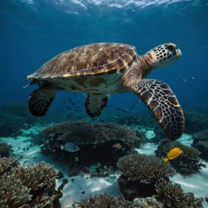
Protecting Vulnerable Species
Marine species face constant threats—some natural, others man-made, such as shipping and fishing. Conservation strategies aimed at protecting vulnerable species would greatly benefit from the analysis of AIS data.
Ship strikes pose a significant danger to species such as whales, which often share a habitat with large vessels. By looking at AIS data, scientists can find patterns in ship movements and thus pinpoint areas of high collision risk. This information can lead to the establishment of measures such as shipping lane adjustments or speed limits to lessen the likelihood of strikes.
For species that are endangered and have been given AIS-compatible tags, AIS will show their movements. Consequently, the information gained regarding migration patterns and habitat use would help influence the creation of marine protected areas.
Protecting Marine Habitats
Human activities disrupt marine ecosystems. Conservationists use AIS data to measure the health of such habitats and develop strategies for reducing damage.
Patterns of vessel traffic in areas near sensitive habitats like coral reefs, seagrass beds, and mangroves can be a key monitoring tool. Anchor damage and pollution from vessels creating heavy traffic can severely impact such ecosystems. By analyzing AIS data, policymakers can create regulations to minimize such threats, for instance, by establishing no-anchoring zones.
AIS can play a role in the enforcement of marine protected areas (MPAs). By tracking the entry and exit of vessels from such areas, it would be possible to more efficiently control and prevent unauthorized activities, such as fishing or resource extraction.
 Linking Technology with Community Initiatives
Although hard data may be offered by technology such as AIS, its power is amplified when combined with local knowledge and efforts from the community. Local communities, particularly those in coastal and island nations, often rely heavily on marine resources. Involving these communities in conservation initiatives using AIS data not only supports ecological principles but also boosts worldwide socio-economics.
When local fishers understand vessel activity in real-time, they are able to steer clear of crowded areas, which in turn minimizes bycatch and damage to fishing gear. Furthermore, community-based monitoring programs can apply AIS data to identify illegal activities and inform the relevant authorities.
Ensuring conservation measures are realistic and culturally appropriate is achieved by working with local stakeholders. It’s this kind of synergy that turns conservation from a top-down approach into an inclusive enterprise, where communities become the guardians of their marine areas.
The Path of Innovation
Machine learning is one of the innovations that can enrich AIS data analysis. By recognizing patterns and anomalies, it would help detect things that humans cannot notice.
Bringing together AIS with further geospatial data, such as satellite imagery, can supplement the information available about the marine environment. This joint approach can play a significant role in monitoring and enforcing Fisheries Management Zones (FMZs) and sustaining practices in fishery, among other things.
Research and development investments aimed at enhancing AIS technology will be fundamental in meeting climate change challenges, overfishing, and pollution and habitat destruction issues. The innovation path offers the hope of stronger conservation measures, leading to healthier oceans and more resilient ecosystems.
Overcoming Challenges
There are still hurdles in marine conservation with the increased use of AIS data. One of the biggest problems is the accuracy and availability of data. Not all ships have AIS transmitters, especially smaller and recreational boats–this creates data gaps.
Given the millions of data points created every day, data management and analysis must be efficient. It is key to build analytical tools that are both powerful and simple, making it easier to turn this data into insights that can drive action.
Although AIS can track vessel movement, it cannot measure directly the impact that such movement has under the water, such as noise pollution from ships or direct disturbances to marine life. New tools and technologies, complementary to AIS, need to be developed in order to capture these items, thereby allowing a more complete approach to conservation.
A Shared Responsibility
Bringing AIS into the MC field will require the cooperation of various sectors such as Governments, NGOs, scientists, and the private sector. They should work together to increase the scope of AIS. Enhance analytical methods, and implement data-driven conservation strategies.
Equally important is the public understanding and awareness of the technology behind AIS in order to support marine conservation initiatives. Demonstrating the success stories and direct benefits to biodiversity can push actions at the local and international levels.
Conservation of marine biodiversity and marine habitats is a common responsibility. Accepting technologies like AIS is necessary to achieve collective stewardship of our oceans for the future.